

Caneel Hill Trail Round Trip
-
turtlegirl
- Posts: 154
- Joined: Sat Mar 01, 2008 8:54 pm
- Location: Massachusetts
Caneel Hill Trail Round Trip
I've read about doing a Caneel Hill loop, and I'd like to make sure I understand the directions correctly. Starting in Cruz Bay, you go up the hill then East over Margaret Hill to the North Shore Road, across from Caneel Bay Resort. The suggested loop is using the Lind point trail to connect. The only way I can see doing that is to walk across Northshore Rd. into the Caneel Bay resort and then to the Lind Point trail, which will bring you back to Cruz Bay at the NP visitors center. Can you please tell me if this is correct?

Looking at the Trailbandit and NPS maps, it looks like you got it right. You can see where the trail head is on the road near Caneel Bay. You can walk into Caneel Bay and tell them where you are headed and they will give directions to Honeymoon Bay, where you'll pickup the trail.
There's a good description here: http://www.seestjohn.com/trails_caneel_hill.html
Caneel Hill is 719 feet and Margaret Hill is 820 feet. Your going to get some great views!
Cheers, RickG
There's a good description here: http://www.seestjohn.com/trails_caneel_hill.html
Caneel Hill is 719 feet and Margaret Hill is 820 feet. Your going to get some great views!
Cheers, RickG
S/V Echoes - Coral Bay - St. John, VI
-
turtlegirl
- Posts: 154
- Joined: Sat Mar 01, 2008 8:54 pm
- Location: Massachusetts
Thanks, Rick. The link you just posted is actually where I got the info. from! I think we'll actually start at the NPS visitors center, take the Lind point trail, walk through the resort and head up Margaret hill. This way we won't be so sweaty/dirty walking through Caneel Bay and the ascent up Margaret Hill is less steep than up Caneel Hill on the other side. If anybody has done this or similiar, please let me know.
I would really consider doing the loop the other direction. That way you can do a swim at Honeymoon or Salomon on the way back! No bathing suit?
Sweaty at Caneel? Perish the thought!
Sounds like fun.
We've never done the Caneel Hill Trail. Sweet Christine does not like walking up hills. But, we have gotten her to do a 1600 foot climb here in Virginia. She called me a bad name on the way up.
Cheers, RickG
Sweaty at Caneel? Perish the thought!
Sounds like fun.
We've never done the Caneel Hill Trail. Sweet Christine does not like walking up hills. But, we have gotten her to do a 1600 foot climb here in Virginia. She called me a bad name on the way up.
Cheers, RickG
S/V Echoes - Coral Bay - St. John, VI
-
Dave-a-roni
- Posts: 299
- Joined: Fri May 25, 2007 1:43 am
- Location: Western NY
It's a nice trsil turtlegirl, lots of interesting plantlife. Starting from the NPS building is a good idea, good parking if your driving to the NPS building at the begining of the Lind trail.
"Try to preserve nature where you live, not just where you visit"
Photo's
2008 http://www.flickr.com/photos/dave-a-ron ... 118102515/
2005 http://www.flickr.com/photos/dave-a-ron ... 326642810/
Photo's
2008 http://www.flickr.com/photos/dave-a-ron ... 118102515/
2005 http://www.flickr.com/photos/dave-a-ron ... 326642810/
I know I must have gotten lost on this trail
It was probably the hardest trail I have done - partly due to the time it took as I was not expecting this and the huge "gut" I had to climb down to exit to the raod - it took about 2 1/2 hours without doing the full loop - I started at Mongoose and ended at Caneel - I cringe each time I drive past the start
Pia
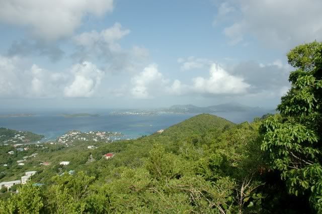
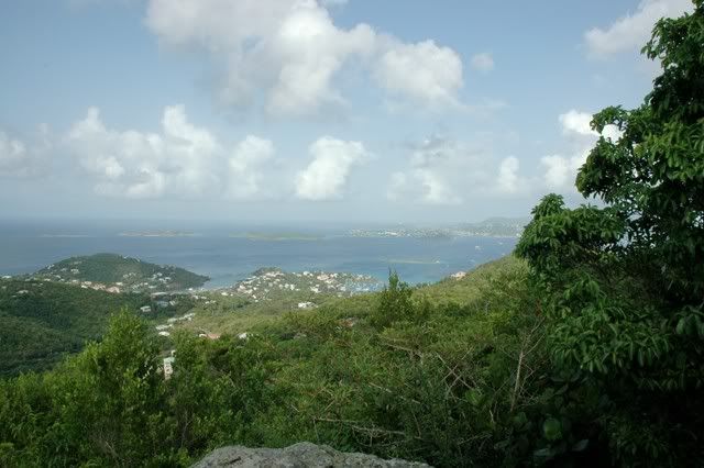
TG - Here's a couple of shots bayer took last year from an overlook on Caneel Trail. We hiked from the cottage to the overlook then back to the cottage. That was plenty of hiking for me. I'm with NoTanLines on this subject. 
It is beautiful, though. I'm sure if you're a hiker, you'll love it.
It is beautiful, though. I'm sure if you're a hiker, you'll love it.
When the end of the world comes, I want to be in Kentucky, because everything there happens 20 years after it happens anywhere else. – Mark Twain
I use Gerald Singer's "St. John Off the Beaten Track." Seestjohn.com is run by that crew. The NPS maps show their official maintained trails. But, there's a lot more out there.
Try the Leinster Bay, Brown Bay and Coral Bay walk with two cars. Its a great one-way walk. If you do the loop you get to slog up Johnny Horn trail.
I need to try to get Sweet Christine to do the Lindt Point trail with me in November. It looks flat enough for her.
Cheers, RickG
Try the Leinster Bay, Brown Bay and Coral Bay walk with two cars. Its a great one-way walk. If you do the loop you get to slog up Johnny Horn trail.
I need to try to get Sweet Christine to do the Lindt Point trail with me in November. It looks flat enough for her.
Cheers, RickG
S/V Echoes - Coral Bay - St. John, VI
-
turtlegirl
- Posts: 154
- Joined: Sat Mar 01, 2008 8:54 pm
- Location: Massachusetts
Thanks for the advice on saving the beach for last-we'll do that. Coffee at the Deli Grotto sounds good, too. The trailbandit will send you a map if you write to him. His address is on his website. I also have a question about the Reef Bay Trail-we will be climbing back up and I was wondering if we went back up l'Esperance how long a walk on Centerline Road is it between the 2 trailheads? Or should we just hike back up the RB trail-we don't want to do the organized hike/boat ride back. Besides Caneel Hill and Reef Bay, we'd like to do one more 2 hour plus hike and are looking at Johnny Horn trail as we won't have 2 vehicles. Is this a good option? Also, in STJOTBT, he recommends a Leinster Bay spur trail to be closer as you start your swim to Waterlemon Cay, does anybody do this? And one more thing, if we want to do a kayak, where should we get the kayak from and where should we kayak? Thank you all soooo much.
I need to try to get Sweet Christine to do the Lindt Point trail with me in November. It looks flat enough for her.
Cheers, RickG[/quote]
Tell Christine The Lind Point Trail isn't bad at all if you want a lower key hike. We did take the lower trail to Solomon, then Honeymoon and Caneel so we didn't get to the top of Lind Point, the upper trail. (We weren't sure where we were going). That said, the last time we parked at Caneel and walked in  .
.
Cheers, RickG[/quote]
Tell Christine The Lind Point Trail isn't bad at all if you want a lower key hike. We did take the lower trail to Solomon, then Honeymoon and Caneel so we didn't get to the top of Lind Point, the upper trail. (We weren't sure where we were going). That said, the last time we parked at Caneel and walked in
Going "home" again October 26th!

Coming back from Reef Bay via L'Esperance is definitely longer than going up the way you came down. The trailheads are about 1.5 miles apart on Centerline, but that leg would not include any steep up-hills...
Most of the elevational gain is at the beginning, coming up to Mollendal, and it can be pretty exposed, i.e. hot. Nice walk, though.
Many people, including me, use the spur trail out to Waterlemon Point before snorkling out to the cay.
Most of the elevational gain is at the beginning, coming up to Mollendal, and it can be pretty exposed, i.e. hot. Nice walk, though.
Many people, including me, use the spur trail out to Waterlemon Point before snorkling out to the cay.