

Umbrellas? We don't need no stinkin' umbrellas!(Pt. IV)

Umbrellas? We don't need no stinkin' umbrellas!(Pt. IV)
Link to Pt. I - http://virgin-islands-on-line.com/forum ... 206#205206
Link to Pt. II - http://virgin-islands-on-line.com/forum ... hp?t=17483
Link to Pt. III - http://virgin-islands-on-line.com/forum ... hp?t=17487
Friday, July 17 - Broken record time. Woke up to wind/clouds/rain. Had breakfast. Coffee filters bought at Lily's were the wrong kind, so walked to Big Ben's for the morning cup of coffee. Ate breakfast, got cameras and gear ready, woke up the teenager.
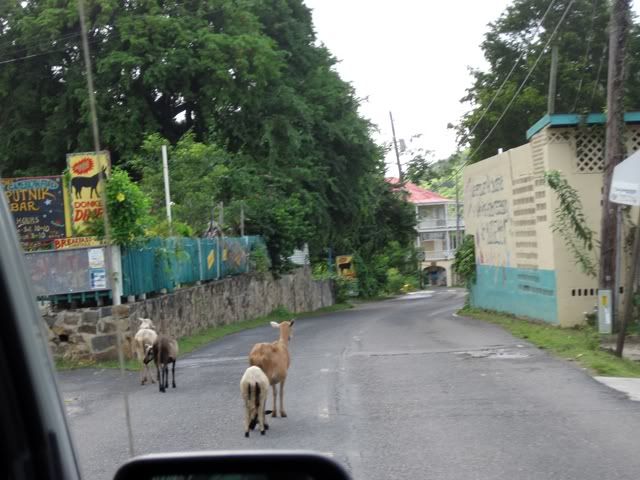
We decided to head east, *hoping* that we'd be able to snorkel Haulover North for the first time. Along the way, we were slowed by some Coral Bay commuter traffic:
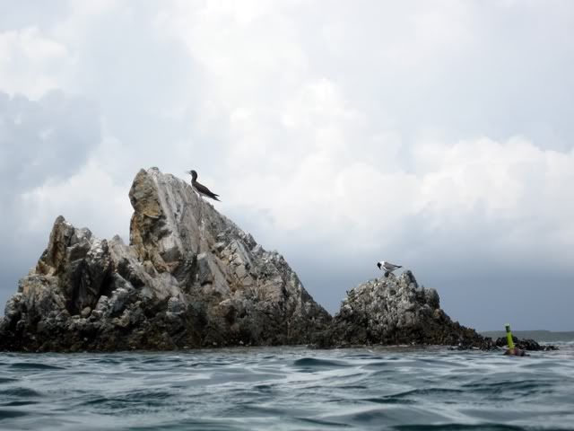
As soon as we cleared the "traffic jam" we continued east until we parked just off of the road at Haulover South. After a quick consultation with "Feet, Fins, and Four Wheel Drive" we crossed the street, found the trail and walked the five minutes or so through the brush then exited onto the rocky beach. The wind was mostly in our faces and there were fairly consistent whitecaps breaking just a few feet off of the beach. As badly as we wanted to snorkel here, we knew that these weren't going to be great conditions to do so, particularly for the first time. So we backtracked out to the street, crossed, got out the gear, and prepared to snorkel Haulover South - not a bad consolation prize!
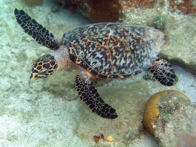
We had been very surprised that after snorkeling at Blue Cobblestone, Salt Pond Bay, and twice at Little Lameshure, that we had yet to see a turtle. So we were very pleased that shortly after entering the water, as we made our way along the rocks lining the left side of the bay, to come upon this little hawksbill:
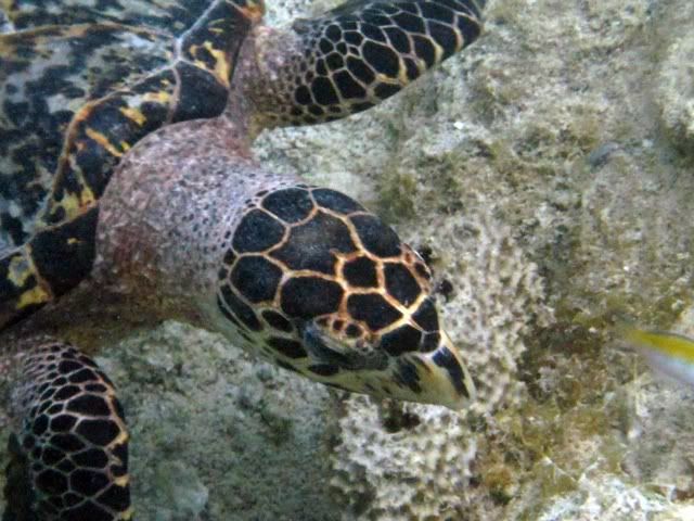
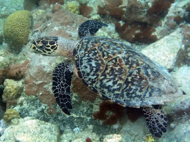
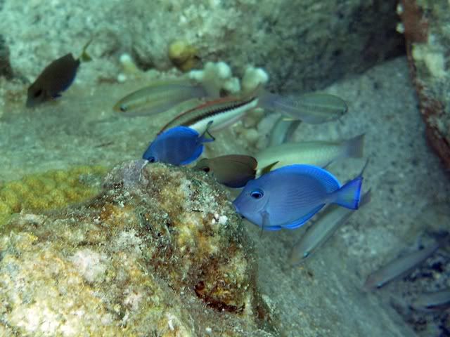
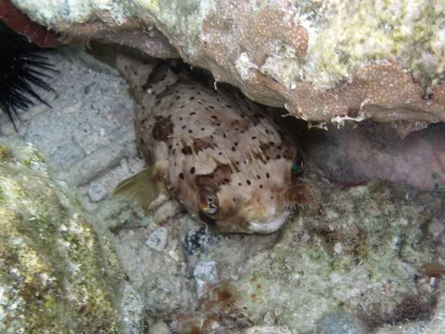
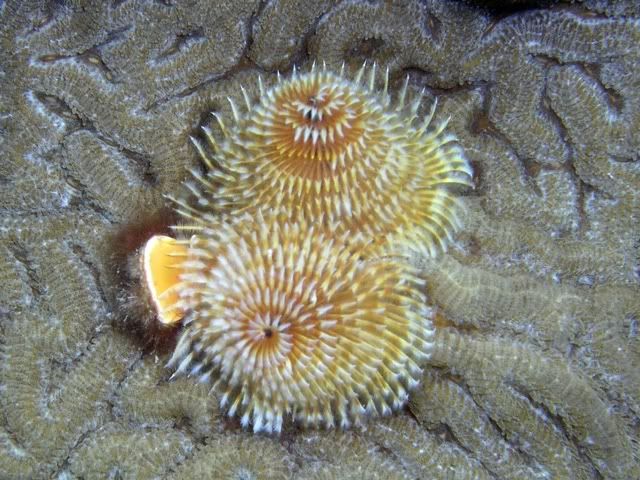
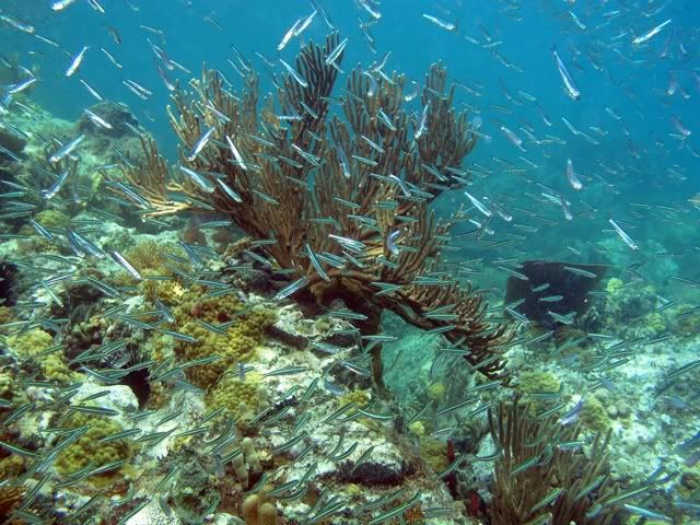
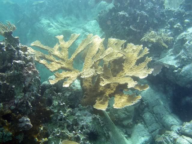
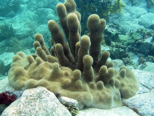
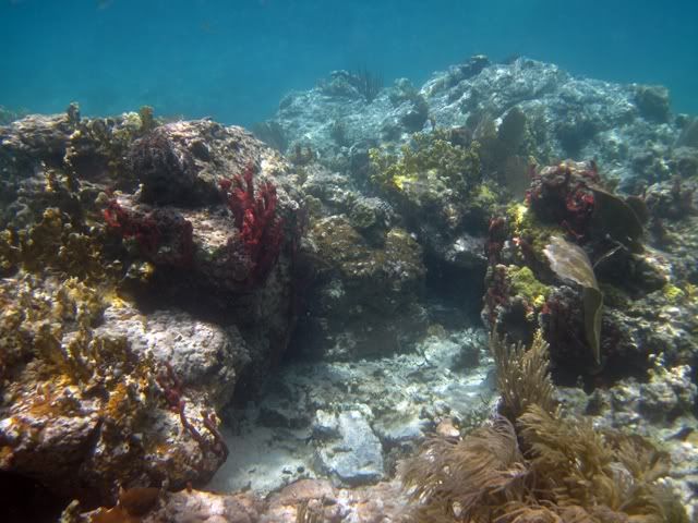
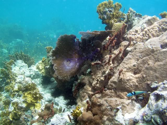
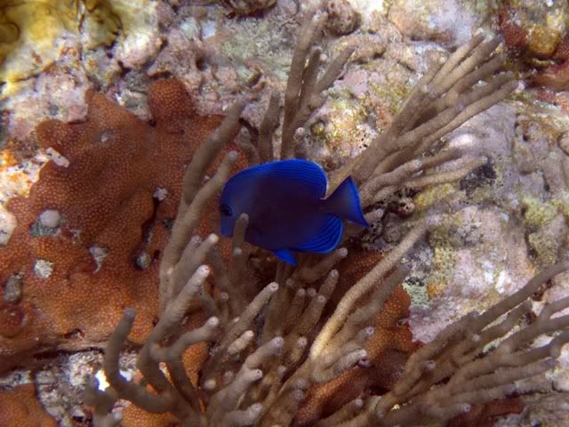
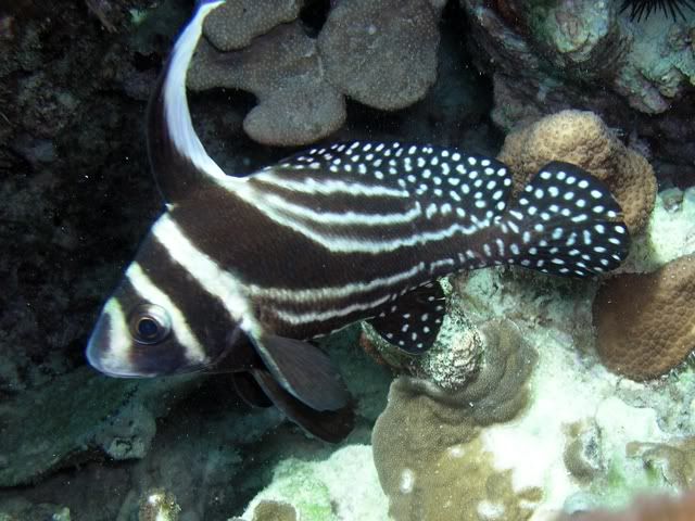
After he got tired of us we continued along the left side and made our way out to the point, enjoying the underwater flora and fauna along the way:
Once we got out to the point it was a little too rough to try to go beyond, so we opted to swim across the mouth of the bay to the point at the far side, where we'd make our way back to our entry point by following the shoreline near the rocks. It's kind of eerie when you get out over water that's too deep to see the bottom. In late to mid morning, when you're crossing the bay from east to west, the sun is at your back and the rays penetrating the water resemble laser beams that illuminate the shallow water and then gradually disappear.
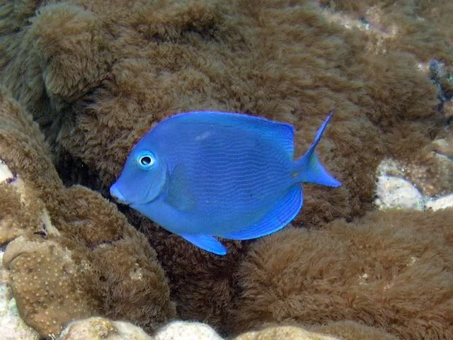
We made it to the other side and picked right up where we left off, seeing all of the cool stuff underwater STJ has to offer.
I heard Leslie calling my name (could she have founder her elusive eagle ray - in this most unlikely of places? - sadly, no) and lifted my head out of the water to see what was up. I was surprised to see her not pointing to the water, but rather up, above the rocks. Once I looked up, I saw why.
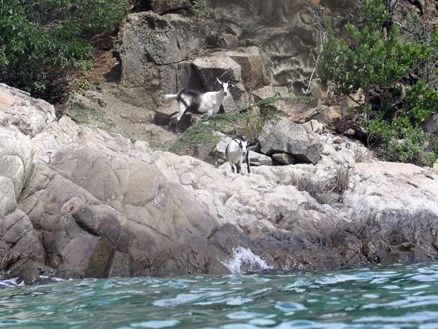
These guys (there were three in all) seemed to be as surprised to see us as we were to see them. After looking at each other for a few minutes they continued on their way (up the hill), and we on ours.
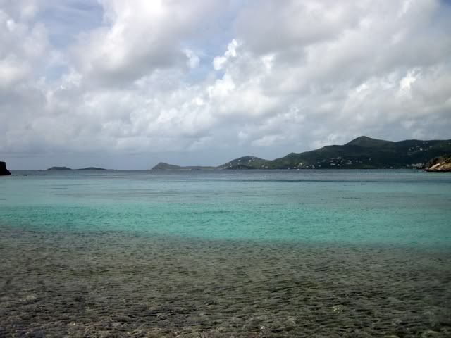
Leslie started getting cold, and wanted to change the battery in her camera (it had died shortly after we saw the turtle) so she went in while Jason and I poked around the shallows for a bit longer.
Camera re-energized, Leslie took a picture of the bay, as seen from our entry point.
After we dried off a little we packed the jeep back up and continued east, as far as we could go on "the highway". We parked next to the dumpster and walked alongside a fence to the rocky beach in front of Pelican Rock. (Disclaimer: We "think", based on what we've read in FF&4WD, that this is Pelican Rock - we've also heard some indirect descriptions that lead us to believe that we may not be talking about the same place that others have, so caveat emptor!)
We entered the water somewhat left of where the rocks are exposed, and navigated a diagonal path towards them. It seemed to me, and Leslie concurred when we talked about it later, that there is a good bit more coral and sea life here than we remembered from our first visit, in 2007.
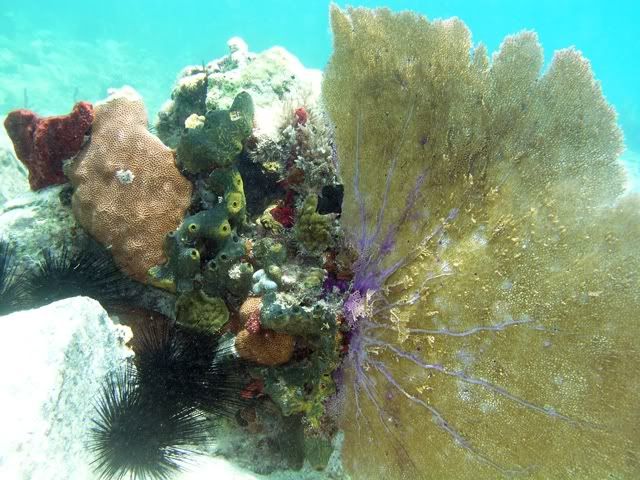
Soon we approached the rocks that define (for us) the site Pelican Rock.
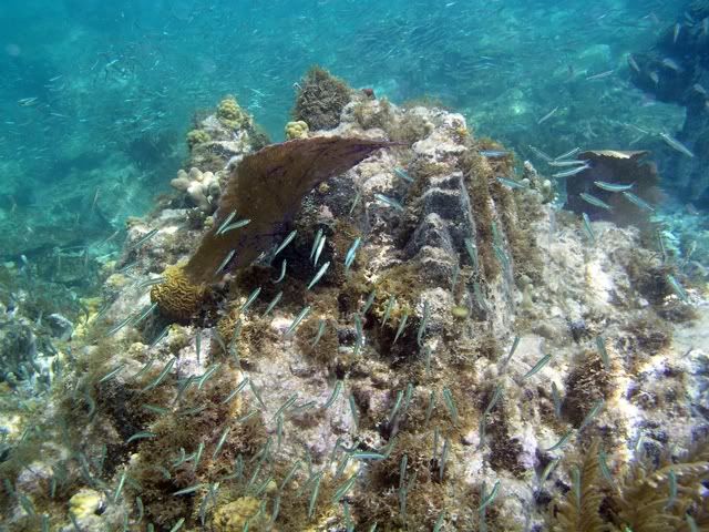
Just south of the rocks that make up Pelican Rock is a series of coral heads that provide some pretty good snorkeling in their own right - they are straight off of where we entered the water.
Once we got out of the water we dried off, took our gear back to the jeep, and made the short drive up to Sloop Jones' studio. Slop was changing a flat tire as we pulled up, and declined my offer to help (maybe he saw me changing the tire at Brown Bay a couple of trips back!)
We found Barbara having lunch and interrupted her long enough to give her some t-shirts Leslie had brought them from our local Relay for Life event. They had been kind enough to provide an original Sloop Cancer Ribbon shirt to be raffled off at our event, so we wanted to see that they got a token of thanks for their generosity.
While Jason and I hung out on the porch at the studio/store, Leslie did enough shopping to find a cute shirt that she liked. After we bought it we had to wait out a little rainstorm, or at least wait until it let up enough for us to dash back to the jeep.
On our way back we saw that we weren't the only ones caught out in the rain.
The rain was coming down pretty steady, and we were really hungry by now, so we stayed on the road until the jeep turned into the parking lot at Shipwreck Landing. Jason enjoyed his burger, Leslie her mahi sandwich, and I had one of the lunch specials - scallop quesadillas - awesome!
After rinsing off the gear and ourselves, we headed into town to take care of some business. Just past the smoothie stand we picked up a teenage girl hitchhiking into town, who was going over to St. Thomas to meet friends at a concert. After dropping her off by the ferry dock we headed to the Lumberyard complex where we refilled several of our gallon water bottles for fifty cents apiece at St. John ice - what a bargain!
We made a stop by St. John Spice and were happy that Ruth was in! She actually had some "spare" coffee filters that she gave us, as well as a couple of other things from her "free box". Then we headed towards Pine Peace but couldn't find a place to park, so we went to the new St. John Market, just past the Westin.
On the way home we decided that we might as well head up Jacob's Ladder so that we could show Jason the South Shore Rd/Gifft Hill Rd. route we had taken so many times on our first trip. All of our favorite switchbacks were intact, but we were pleased to see how much of lower Gifft Hill Rd. was paved - what a difference.
The rest of the day was routine - back "home", get cleaned up, have dinner (pulled pork from my smoker!), download pictures, Facebook, zzzzzzzzzz.......
Link to Pt. II - http://virgin-islands-on-line.com/forum ... hp?t=17483
Link to Pt. III - http://virgin-islands-on-line.com/forum ... hp?t=17487
Friday, July 17 - Broken record time. Woke up to wind/clouds/rain. Had breakfast. Coffee filters bought at Lily's were the wrong kind, so walked to Big Ben's for the morning cup of coffee. Ate breakfast, got cameras and gear ready, woke up the teenager.
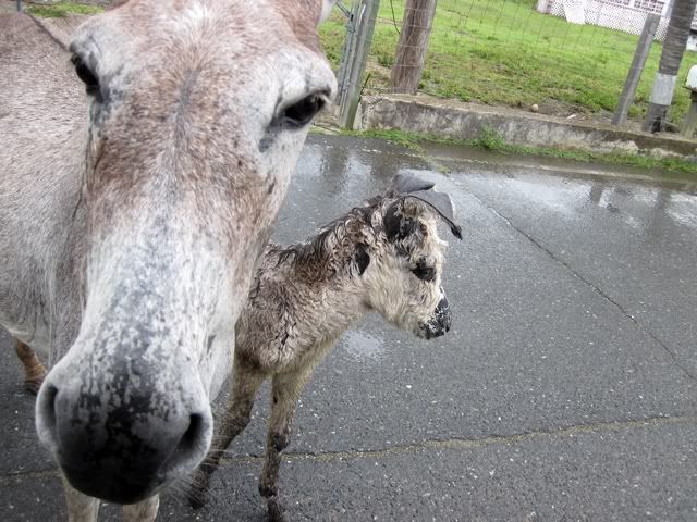
We decided to head east, *hoping* that we'd be able to snorkel Haulover North for the first time. Along the way, we were slowed by some Coral Bay commuter traffic:
As soon as we cleared the "traffic jam" we continued east until we parked just off of the road at Haulover South. After a quick consultation with "Feet, Fins, and Four Wheel Drive" we crossed the street, found the trail and walked the five minutes or so through the brush then exited onto the rocky beach. The wind was mostly in our faces and there were fairly consistent whitecaps breaking just a few feet off of the beach. As badly as we wanted to snorkel here, we knew that these weren't going to be great conditions to do so, particularly for the first time. So we backtracked out to the street, crossed, got out the gear, and prepared to snorkel Haulover South - not a bad consolation prize!
We had been very surprised that after snorkeling at Blue Cobblestone, Salt Pond Bay, and twice at Little Lameshure, that we had yet to see a turtle. So we were very pleased that shortly after entering the water, as we made our way along the rocks lining the left side of the bay, to come upon this little hawksbill:
After he got tired of us we continued along the left side and made our way out to the point, enjoying the underwater flora and fauna along the way:
Once we got out to the point it was a little too rough to try to go beyond, so we opted to swim across the mouth of the bay to the point at the far side, where we'd make our way back to our entry point by following the shoreline near the rocks. It's kind of eerie when you get out over water that's too deep to see the bottom. In late to mid morning, when you're crossing the bay from east to west, the sun is at your back and the rays penetrating the water resemble laser beams that illuminate the shallow water and then gradually disappear.
We made it to the other side and picked right up where we left off, seeing all of the cool stuff underwater STJ has to offer.
I heard Leslie calling my name (could she have founder her elusive eagle ray - in this most unlikely of places? - sadly, no) and lifted my head out of the water to see what was up. I was surprised to see her not pointing to the water, but rather up, above the rocks. Once I looked up, I saw why.
These guys (there were three in all) seemed to be as surprised to see us as we were to see them. After looking at each other for a few minutes they continued on their way (up the hill), and we on ours.
Leslie started getting cold, and wanted to change the battery in her camera (it had died shortly after we saw the turtle) so she went in while Jason and I poked around the shallows for a bit longer.
Camera re-energized, Leslie took a picture of the bay, as seen from our entry point.
After we dried off a little we packed the jeep back up and continued east, as far as we could go on "the highway". We parked next to the dumpster and walked alongside a fence to the rocky beach in front of Pelican Rock. (Disclaimer: We "think", based on what we've read in FF&4WD, that this is Pelican Rock - we've also heard some indirect descriptions that lead us to believe that we may not be talking about the same place that others have, so caveat emptor!)
We entered the water somewhat left of where the rocks are exposed, and navigated a diagonal path towards them. It seemed to me, and Leslie concurred when we talked about it later, that there is a good bit more coral and sea life here than we remembered from our first visit, in 2007.
Soon we approached the rocks that define (for us) the site Pelican Rock.
Just south of the rocks that make up Pelican Rock is a series of coral heads that provide some pretty good snorkeling in their own right - they are straight off of where we entered the water.
Once we got out of the water we dried off, took our gear back to the jeep, and made the short drive up to Sloop Jones' studio. Slop was changing a flat tire as we pulled up, and declined my offer to help (maybe he saw me changing the tire at Brown Bay a couple of trips back!)
We found Barbara having lunch and interrupted her long enough to give her some t-shirts Leslie had brought them from our local Relay for Life event. They had been kind enough to provide an original Sloop Cancer Ribbon shirt to be raffled off at our event, so we wanted to see that they got a token of thanks for their generosity.
While Jason and I hung out on the porch at the studio/store, Leslie did enough shopping to find a cute shirt that she liked. After we bought it we had to wait out a little rainstorm, or at least wait until it let up enough for us to dash back to the jeep.
On our way back we saw that we weren't the only ones caught out in the rain.
The rain was coming down pretty steady, and we were really hungry by now, so we stayed on the road until the jeep turned into the parking lot at Shipwreck Landing. Jason enjoyed his burger, Leslie her mahi sandwich, and I had one of the lunch specials - scallop quesadillas - awesome!
After rinsing off the gear and ourselves, we headed into town to take care of some business. Just past the smoothie stand we picked up a teenage girl hitchhiking into town, who was going over to St. Thomas to meet friends at a concert. After dropping her off by the ferry dock we headed to the Lumberyard complex where we refilled several of our gallon water bottles for fifty cents apiece at St. John ice - what a bargain!
We made a stop by St. John Spice and were happy that Ruth was in! She actually had some "spare" coffee filters that she gave us, as well as a couple of other things from her "free box". Then we headed towards Pine Peace but couldn't find a place to park, so we went to the new St. John Market, just past the Westin.
On the way home we decided that we might as well head up Jacob's Ladder so that we could show Jason the South Shore Rd/Gifft Hill Rd. route we had taken so many times on our first trip. All of our favorite switchbacks were intact, but we were pleased to see how much of lower Gifft Hill Rd. was paved - what a difference.
The rest of the day was routine - back "home", get cleaned up, have dinner (pulled pork from my smoker!), download pictures, Facebook, zzzzzzzzzz.......
Come see us!
-
bayer40601
- Posts: 612
- Joined: Sun Oct 14, 2007 1:06 pm
- Location: Kentucky
Another great report and outstanding pictures Augie. A few trips back, Pam, Heather and a friend of Heather's snorkeled from the same area near Pelican Rock, but instead of heading out toward the Rock, they went left over toward Long Point. I don't think they found much in the way of fish, coral or other sea life, so next time I will have to encourage them to head out toward Pelican. Also, we have always wondered about Haulover, and I think you have answered those questions. Thanks again for your wonderful reports.
How many more days?


Great photos, Steve, especially the one of the Spotted Drum - might have been the best shot of that fish I've seen here.
The photo sure looks like Pelican Rock. There are multiple ways to get there. We've done via Long Bay (sounds like this is the route you took) and also via Vie's other (no-fee) beach. We enjoyed both routes.
The photo sure looks like Pelican Rock. There are multiple ways to get there. We've done via Long Bay (sounds like this is the route you took) and also via Vie's other (no-fee) beach. We enjoyed both routes.
I am LOVING your pics and trip report. Keep them coming!
My husband saw the red underwater camera case and was wondering what type of camera you are using?
Great shots. Makes me want to hop on the plane to STJ and go snorkeling. Seems like you were snorkeling for a really long time before you ate again. That's a lot of activity on the nutrition of a pop-tart - LOL.
Great report Augie and awesome photos...thanks so much for posting your TR!
Cheers
Cheers
STJ Villa Map:
http://maps.google.com/maps/ms?hl=en&ie ... 2&t=h&z=14
http://maps.google.com/maps/ms?hl=en&ie ... 2&t=h&z=14
That photo of the wet baby donkey is cute and really cracked me up at the same time.
Scallop quesadillas lunch special at Shipwreck?
Man, that sounds good. I'll have to kindly request if they could make that up for me next out there.
Scallop quesadillas lunch special at Shipwreck?
Man, that sounds good. I'll have to kindly request if they could make that up for me next out there.
When we come to place where the sea and the sky collide
Throw me over the edge and let my spirit glide
Throw me over the edge and let my spirit glide


-
SOonthebeach

- Posts: 1707
- Joined: Tue Jan 19, 2010 10:01 am
- Location: Texas


My husband saw the red underwater camera case and was wondering what type of camera you are using?
Thanks! I use (and have been for a number of years) an Olympus C5050 camera with a dedicated Olympus PT-015 underwater housing. I can take this rig to well below 100 feet deep when scuba diving.I would also love to know what kind of camera you are using. Pictures are great! Thanks for the continued TR!
This trip we were a two camera group (for most of the trip - details in a coming installment) as my wife got a Canon D10 camera for her birthday. The photos in the trip reports come from both!
Come see us!