

Drunk Bay trail?
-
stjohnnewbie
- Posts: 58
- Joined: Wed Jul 28, 2010 9:37 am
Drunk Bay trail?
Hi!
Writing from first trip to St. John. Have really enjoyed reading the forum over the last few weeks. Thanks!
I want to visit Drunk Bay. Found the sign and the red pond (was told the sand is spa magic for your skin - true, or locals pulling tourists' legs for giggles?), but absolutely no trail. Is it typically along the left side, right on the shore? Explored all around and couldn't find any trail. Made an attempt to walk through the forested area, but was attacked by a swarm of angry and relentless bugs. Thought maybe the trail could be flooded out from the rains last week, but a bartender last night told us she was out there just three or four days ago. Any ideas?? Enjoyed Salt Pond Bay Beach at any rate!
Thanks for any guidance you can give.
~ E

-
SOonthebeach

- Posts: 1707
- Joined: Tue Jan 19, 2010 10:01 am
- Location: Texas

-
mindehankins
- Posts: 3014
- Joined: Fri Mar 06, 2009 8:21 am
- Location: Western NY State
From what I recall, you head straight back behind the sign, and there's an obvious path/trail that is narrow but again, obvious. It does run parallel to the salt pond, but not right along it's shore. You'd have to jump down to the shore line, from the path...it's elevated some.
It's worth waiting for the water to recede, and try to find the path again, to see Drunk Bay.
Enjoy!
It's worth waiting for the water to recede, and try to find the path again, to see Drunk Bay.
Enjoy!
-
stjohnnewbie
- Posts: 58
- Joined: Wed Jul 28, 2010 9:37 am
-
bayer40601
- Posts: 612
- Joined: Sun Oct 14, 2007 1:06 pm
- Location: Kentucky
I was there on Sunday with the intent to go over to Drunk Bay. You take the path from the Salt Pond Bay beach up a little rise, then down to the water's edge at Salt Pond. Before the heavy rains, the path to Drunk Bay began right at waters edge at Salt Pond (not the Bay) On Sunday, the water was at least 18", maybe 2 feet over the path along waters edge. Like others I looked for a way back through the brush and bushes to the trail after it leaves the Salt Pond waters edge, but it was simply too thick, since I did not have my machete. 
Also, any of you who have been over there since the rains will notice there is no salt accumulation at this time due to the high water, but I can imagine this fall will yield a bumper harvest of salt.
Also, any of you who have been over there since the rains will notice there is no salt accumulation at this time due to the high water, but I can imagine this fall will yield a bumper harvest of salt.
How many more days?

I'd love to see a pic of what it looks like over there now. If it's flooded, it would make sense that you couldn't see the trail. With so many Catch-n-keep bushes and cactii you definitely wouldn't want to pbalze your own path.
Even on a godo day the path is what I call a "Billy Goat" trail. It's narrow (albeit relatively flat and not that rocky) and lined with all kinds of plant life designed to ruin your bathing suit. So wear clothes and shoes.
The place always seems otherworldly to me and have posted pics formt he hike several times on this forum (just search Drunk Bay and you should find some).
As for the mud-- it's not a joke. I think it was the Park Service that lead a "Nature Spa Tour" over to the Salt Pond on the way to Drunk Bay several months ago. The ranger encouraged everyone to smear mud on them. (Must have looked like Woodstock!) I think one forumite did that tour and actually posted a review of the adventure.
I suppose if you are adventurous (and if the trail clears up) I would walk to Drunk Bay and on the way back partake of the mud experience. Then it will dry as you walk back to the beach. Once at the beach you can dive in and use the sand and surf to scrub off. I'd be careful of getting it on your bathing suit though in case it stains.
If you are brave, go for it, but I am not a big fan of putting my hands into water that I can't see the bottom of (That includes the ocean here at home which is why I love STJ so much!).
Keep us posted!
*Another fine scatterbrained production
-
bayer40601
- Posts: 612
- Joined: Sun Oct 14, 2007 1:06 pm
- Location: Kentucky
Gromit-I have kicked myself many, many times for having not taken a picture. In fact, I had my camera with me for the purpose of taking pictures at Drunk Bay, but completely blanked out on taking a picture of the high water.
I have been to Drunk Bay at least 4 times and must admit the inability to get across the water's edge trail to the trail on land left me confused, but the water's edge was, as I said above, 18" to 2 feet under water.
I have been to Drunk Bay at least 4 times and must admit the inability to get across the water's edge trail to the trail on land left me confused, but the water's edge was, as I said above, 18" to 2 feet under water.
How many more days?
-
stjohnnewbie
- Posts: 58
- Joined: Wed Jul 28, 2010 9:37 am
After reading the latest replies, we decided to skip it today. If we end up on that side of the island tomorrow, I'm sure we'll give it a shot, but I'm not sure if we'll be over there or not. This may just have to be something we see on a subsequent visit.
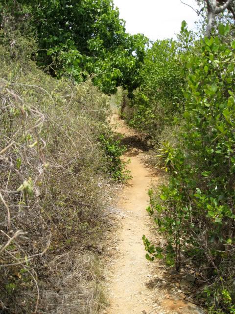
I took this photo the first day. I wish I had taken one of the side where the trail usually is.

I took this photo the first day. I wish I had taken one of the side where the trail usually is.
-
Captain Jack

- Posts: 80
- Joined: Fri Oct 23, 2009 12:32 pm
- Location: Southern Michigan

