Page 1 of 2
STJ Mystery Location
Posted: Sun Feb 03, 2008 11:25 am
by sherban
If I wanted to see this scene on STJ, does anyone know where I would go?

Posted: Sun Feb 03, 2008 12:50 pm
by RickG
Hmm, Peace Hill/Denis Bay looking towards Lovango Cay?
Cheers, RickG
Posted: Sun Feb 03, 2008 3:38 pm
by sherban
Rick- Thanks for taking a shot at it, I'll see if I can rationalize that scenario.
I think it is somewhere over near Waterlemon or Leinster Point looking towards Leinster Bay and Mary creek...I thought the farthest island in the back was JVD...but, of course I'm not sure...
Posted: Sun Feb 03, 2008 3:43 pm
by DELETED
DELETED
Posted: Sun Feb 03, 2008 3:49 pm
by RickG
Brown Bay was my second choice, but I thought that was STT in the distance. From Brown Bay/Leinster Bay the island straight out could be that island with the salt pond due West from Tortola. I can't find the name anywhere.
Sedi/Capt. John?
Cheers, RickG
Posted: Sun Feb 03, 2008 4:05 pm
by mbw1024
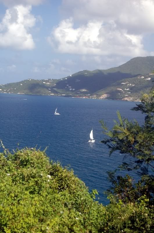
I thought it was out East End way. I took this one the day we headed out to Sloop's.
virtual what?
Posted: Sun Feb 03, 2008 4:06 pm
by sherban
Rick-
This pic was posted on Panoramio/Google Earth as being in Brown Bay and I thought that was incorrect, maybe not..
I was actually trying to do a virtual validation by setting different points of reference in google earth and then adjusting the horizon or "Y-axis reference point" so that the view I see on GE is from ground zero along the horizon rather than looking directly at the earth from above (GE allows adjustment of 3 axis)...you can actually see some things as they look fron earth that way...I thought this might be too weird to post but after reading your other post referring to "canonical", nodes and IP addresses...I figured you had me out-geeked.

)
Posted: Sun Feb 03, 2008 4:08 pm
by mbw1024
this one too
Posted: Sun Feb 03, 2008 5:53 pm
by DELETED
DELETED
Posted: Sun Feb 03, 2008 6:40 pm
by California Girl
SJ - that looks identical, just a different angle.
Posted: Sun Feb 03, 2008 8:13 pm
by DELETED
DELETED
Posted: Sun Feb 03, 2008 8:48 pm
by sunlover
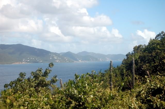
to me, it looks like the view from the Anaberg school, looking toward Mary Point.
is that possible?
Posted: Sun Feb 03, 2008 11:12 pm
by alw1977
I too think it's a view from Annaberg. Here is a similar picture we took back in July. I see that same island mountain with the very large protrusion on one side:

Posted: Sun Feb 03, 2008 11:36 pm
by sherban
Yep, it sure looks like the same perspective as those Annaberg Ruins photos....looking straight out towards JVD right past Anna point (as labeled on Trail Bandit map)...hey- thanks for playing along with the mystery game!
Posted: Mon Feb 04, 2008 9:07 am
by Captain John
It's taken from the Annaberg Sugar Mill Ruins with a very wide angel lens. From left to right, behind the frangipani tree is Anna Point (part of Mary Point), Great Thatch, Jost way in the back, and the little tip on the right is Little Thatch. I would say it's pointing almost due north.