Why Did We Wait So Long? Trip Report 10/15-10/22 Part III
Posted: Thu Oct 25, 2007 2:10 pm
Beaches, beaches everywhere, but not a bite to eat!
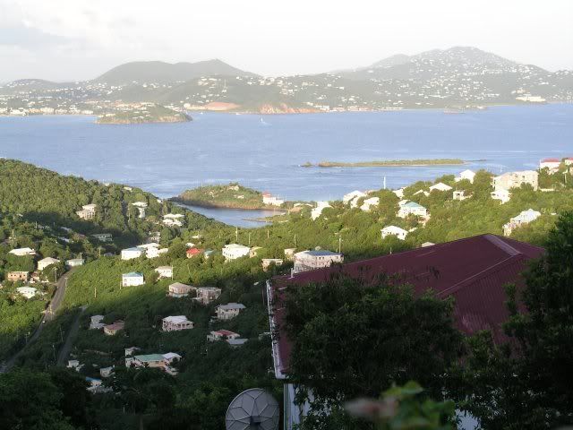
Woke up to another awesome sunrise today:
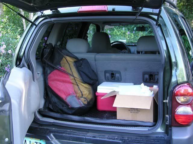
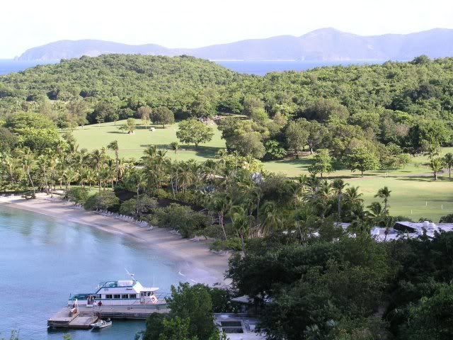
We actually had somewhat of a plan this morning. But we were in no way in too much of a hurry to enjoy breakfast out on the deck. Afterwards, we cleaned up a bit, and loaded the jeep for our adventure (as well as to make our first dumpster run, in case you were wondering what the white bag in the box was):
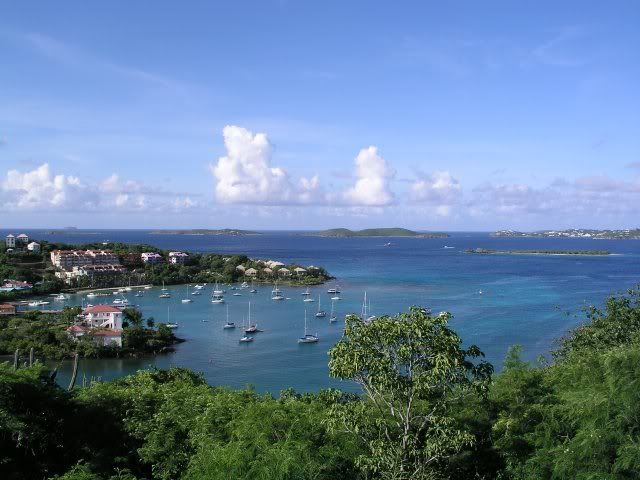
We new there would be cruise ships in STT today, so we wanted to go by and see the beaches along the north shore early, before the crowds got there, then go somewhere where we'd be unlikely to encounter them. We took Gift Hill down to Centerline, and Centerline into town to North Shore. From there we headed east. The first order of business was to take some pictures of the scenic overlooks along North Shore Rd.
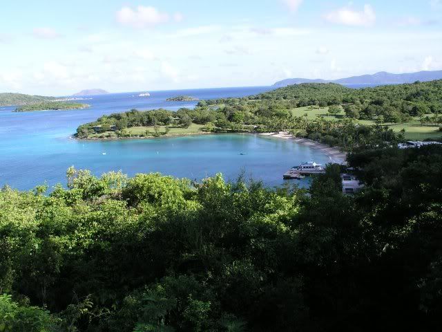
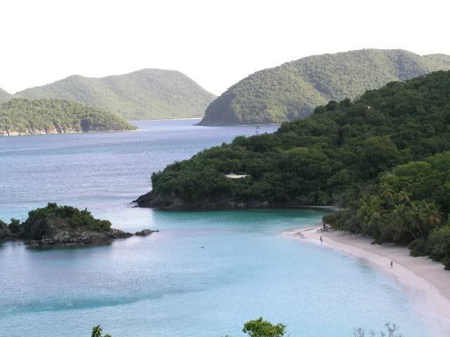
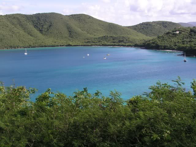
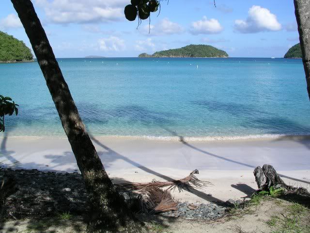
We continued on past all of the north shore beaches - our goal was to go to Waterlemon Cay to snorkel.
By this time we were smart enough to not leave the villa without bringing our copy of "Feet, Fins, and Four Wheel Drive" with us. It led us to the road to the Annaberg ruins where we parked.
A small reading comprehension error on our part had us hiking the road back in the direction we came from for about five minutes before we figured out that we were going the wrong way. No big deal, and if we hadn't gone the wrong way we would not have seen this guy:
Our first STJ donkey!!!
We turned around and headed back the way we wanted to go, and after a few minutes we passed our jeep in the Annaberg parking lot. There was a park ranger at the water's edge adjacent to the parking lot, so we took advantage of her presence to make sure that what we thought was the way to Waterlemon in fact was. She not only made sure that we were pointed in the right direction, but gave us a couple of tips as well (nothing that I hadn't read on here, but she had no way of knowing that).
We headed down the Leinster Bay Trail, and couldn't wait to get into that beautiful water. After about 15 minutes the trail looked like it began to move away from the beach, and there was a sign indicating the start of the Johnny Horn Trail. Confused, we walked on it for a minute or so, and it seemed not only to be going up, but showed no signs of returning to the water's edge. We backtracked, and checked the "bible" once again. We decided that we did not want to go take that trail to try and get closer to Waterlemon Cay. So figured this must be where we entered the water.
As we were getting our gear on, but (luckily) before we started snorkeling, a pair of couples came by, carrying snorkeling gear, and were taking the trail behind the trees, when we asked them if there was a closer place to Waterlemon than where we were, to get in. They had been there before and assured us that there was still more trail near the beach, and that we could get a lot closer. We sure were glad that they happened by when they did! We got out of the water, out of our gear, and back onto the trail (oh! - there it is) and after another five to ten minutes ran out of beach, but found ourself on a rocky shore roughly even with Waterlemon Cay.
As we started making our way out towards the cay we were pleasantly surprised to discover just how close to shore there was "good snorkeling". We even saw a small head of brain coral within six feet of the beach! As we crossed the grass beds on the way out we saw two turtles on the bottom munching out on the grass - how cool!
As suggested on here and by the park ranger, we were circling the cay counter clockwise. When we got to the back side (as referenced from the Leinster Bay Trail) we were amazed to find a HUGE belt of the small, shiny fish (I was calling them silversides, Leslie saw them called fry in one of the books back at the villa). We stopped and marveled at just how many there were. It was a National Geographic moment! The sun was shining down and reflecting here and there off of different ones, occasionally as a grunt would swim through, some of them would scatter, only to rejoin the "formation" again almost instantly. We were mesmerized, and did not want to move since this was so special and likely to end, never to be experienced again, at any moment. (How much do you think I was regretting not bringing the underwater housing for my camera now?)
After more than ten minutes it was obvious that this great horde of tiny fish were going nowhere any time soon, and we did want to see what else was in the area, so a little reluctantly, we moved on. We absolutely LOVED the snorkeling here! Lots of tangs, angelfish, parrotfish, trunkfish, hogfish, as well as the ubiquitous grunts. Very good visibility, until we got about another quarter of the way around and then we couldn't even see the reef - because an even bigger school of silversides was over here. Leslie and I looked at each other, and just laughed and shook our heads - this was unlike anything we'd ever seen!
At one point a bunch of them scattered right in front of us - like the parting of the Red Sea - to reveal three large tarpon, one of them at least six feet long, just feet away from us. Talk about being startled - Leslie grabbed my arm HARD just then!
Once we got to the side closest to the Leinster Bay Trail (just off of where the little beach area on the cay is) I saw one of the famous big starfish! As I slowly floated in its direction I saw another, then another, then another - you get the idea. The starfish party was definitely on! We lost count somewhere around sixty.
We made our way back to shore where we rested, talked to our "neighbors" a bit, and had some water before going back for another lap around the cay.
The second time was more of the excellent snorkeling that we had seen earlier. The silversides were still in abundance, the coral teeming with a variety of sea life, the only thing missing was the turtles that had apparently moved on. We spent some extra time looking for them (and I had us out over the sand quite a bit hoping to spot some stingrays for Leslie), but we finally got tired and decided that we were waterlogged enough for one day.
By the time we got our gear together and made the hike back to the jeep, we realized not only were we a little tired and parched, but it was after 2PM and breakfast was a distant memory - so we needed to eat! Ominously, the backs of Leslie's legs looked pretty darn pink...
OK - so we're hungry, a long way from "home", so what do we do? Why miss the turn to North Shore Road of course! I don't remember if we just went by it without seeing it, or if we thought we could go directly to Centerline, or what, but we missed it. We ended up at a junction where there were three choices.
We chose door #1. That led us to Francis and nowhere else. Back to the triangle.
Door #2 this time. The sign said that we were headed to Maho Camps. The little map we had showed the words "Maho Camps" in the vicinity of where I thought we might want to be, so we headed that way. Quite the rugged road/trail/path, but it looked like another dead end (I didn't think to get out and see if they served late lunch/early dinner).
Obviously door #3 is the one. We crossed a little sign that said Mongoose Crossing. Les said that it looked suspiciously like a private driveway to her, but I said it was probably just a novelty sign like the Iguana Crossing sign near St. John Car Rental. Those of you familiar with the area know whose instincts were right this time. For the rest of you, it wasn't me! This "road" was in fact a pretty steep and narrow driveway with no room to turn around at the top. So we backed down about halfway, very nervously. There is a driveway to another place about halway down (or up depending on which way you're going) and I decided I would back into it in order to be able to contine our descent going forward. It was a fairly sharp turn onto the driveway, and in retrospect I should have though to alert Leslie as to what I was doing. All she knew was that we were going sideways instead of backwards and all I knew was that she was letting me know that something was wrong. Once we caught our breath and ascertained that we were intact, on solid ground, and pointing in the right direction, or at least pointed in the direction we were going, we continued down the hill and back to the three pronged fork in the road.
Since we had exhausted all of our choices and were pretty sure that we weren't in fact in the twilight zone, we thought that our best course of action would be to take the road back towards Annaberg and start over. Naturally we saw the road to our right, which was where we had come in originally this morning, and we took it back towards North Shore Road - it may have actually been North Shore Road - but I was a newbie, hungry, and confused. As a matter of fact, if any of this last part doesn't make sense to those of you that DO know how to get around there, just chalk it up to the excuses I just gave.
Anyway...we eventually came to the smoothie stand so I knew we were at Centerline, so I took a left to go find food in the Coral Bay area. We turned down Salt Pond Rd., but Miss Lucy's looked closed, and I was really looking for Skinny Legs. We stopped where the sign said Jolly Dogs, next to Shipwreck Landing, but both were closed and had some work being done. One of the guys taking a break and drinking a beer on the Shipwreck deck told me what was open and suggested Skinny Legs. And he told me how to find it! So if I had just sayed on Centerline, eh?
We get to Skinny Legs around 3:00PM and the parking lot looks full (I have learned since then that the resourceful people on STJ can find places to park long after the untrained eye thinks there are no more). We are able to get a table, we're in the shade, we can smell food, and a waitress is actually taking our drink orders - life is good! I realize that I have still not had a painkiller on STJ so I order one and Les orders the drink of the day - some mango rum something or the other - but it sounds good, she likes it, and burgers are on the way.
I hadn't had a burger in a while, and I'm sure that being starved might have had something to do with it, but that Bleu Cheese Burger, with sauteed onions and mushrooms, was heavenly! I tore through it, had a second painkiller to wash it down, then was at peace, the kind of peace I came here for, once more.
We drove home (straight home, no inadvertent side trips) and rinsed our gear and ourselves in time to try once again see one of those world famous sunsets. This was about as close as we came to that all week - but no complaints here.
We were too full from our late lunch to even consider making dinner, but Leslie was inspired to make drinks, so we had painkillers(me) and margaritas(Les) until sleep finally over took us.
What a day!
Woke up to another awesome sunrise today:
We actually had somewhat of a plan this morning. But we were in no way in too much of a hurry to enjoy breakfast out on the deck. Afterwards, we cleaned up a bit, and loaded the jeep for our adventure (as well as to make our first dumpster run, in case you were wondering what the white bag in the box was):
We new there would be cruise ships in STT today, so we wanted to go by and see the beaches along the north shore early, before the crowds got there, then go somewhere where we'd be unlikely to encounter them. We took Gift Hill down to Centerline, and Centerline into town to North Shore. From there we headed east. The first order of business was to take some pictures of the scenic overlooks along North Shore Rd.
We continued on past all of the north shore beaches - our goal was to go to Waterlemon Cay to snorkel.
By this time we were smart enough to not leave the villa without bringing our copy of "Feet, Fins, and Four Wheel Drive" with us. It led us to the road to the Annaberg ruins where we parked.
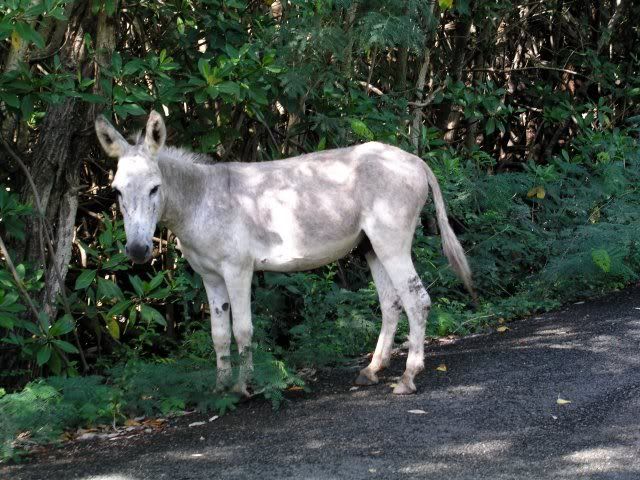
A small reading comprehension error on our part had us hiking the road back in the direction we came from for about five minutes before we figured out that we were going the wrong way. No big deal, and if we hadn't gone the wrong way we would not have seen this guy:
Our first STJ donkey!!!
We turned around and headed back the way we wanted to go, and after a few minutes we passed our jeep in the Annaberg parking lot. There was a park ranger at the water's edge adjacent to the parking lot, so we took advantage of her presence to make sure that what we thought was the way to Waterlemon in fact was. She not only made sure that we were pointed in the right direction, but gave us a couple of tips as well (nothing that I hadn't read on here, but she had no way of knowing that).
We headed down the Leinster Bay Trail, and couldn't wait to get into that beautiful water. After about 15 minutes the trail looked like it began to move away from the beach, and there was a sign indicating the start of the Johnny Horn Trail. Confused, we walked on it for a minute or so, and it seemed not only to be going up, but showed no signs of returning to the water's edge. We backtracked, and checked the "bible" once again. We decided that we did not want to go take that trail to try and get closer to Waterlemon Cay. So figured this must be where we entered the water.
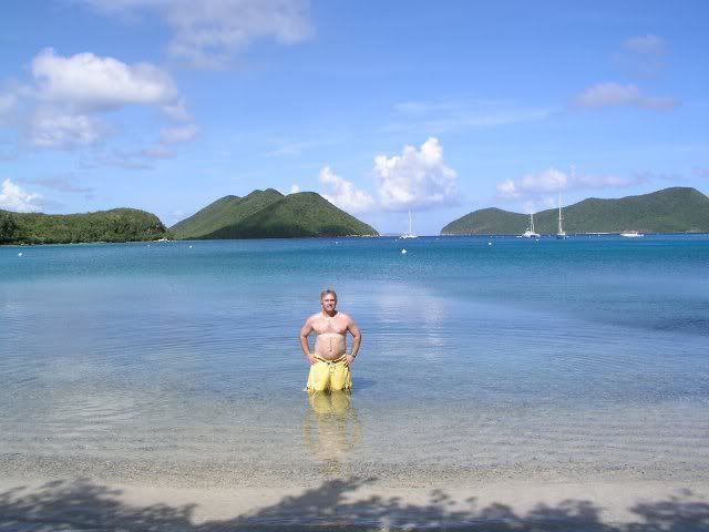
As we were getting our gear on, but (luckily) before we started snorkeling, a pair of couples came by, carrying snorkeling gear, and were taking the trail behind the trees, when we asked them if there was a closer place to Waterlemon than where we were, to get in. They had been there before and assured us that there was still more trail near the beach, and that we could get a lot closer. We sure were glad that they happened by when they did! We got out of the water, out of our gear, and back onto the trail (oh! - there it is) and after another five to ten minutes ran out of beach, but found ourself on a rocky shore roughly even with Waterlemon Cay.
As we started making our way out towards the cay we were pleasantly surprised to discover just how close to shore there was "good snorkeling". We even saw a small head of brain coral within six feet of the beach! As we crossed the grass beds on the way out we saw two turtles on the bottom munching out on the grass - how cool!
As suggested on here and by the park ranger, we were circling the cay counter clockwise. When we got to the back side (as referenced from the Leinster Bay Trail) we were amazed to find a HUGE belt of the small, shiny fish (I was calling them silversides, Leslie saw them called fry in one of the books back at the villa). We stopped and marveled at just how many there were. It was a National Geographic moment! The sun was shining down and reflecting here and there off of different ones, occasionally as a grunt would swim through, some of them would scatter, only to rejoin the "formation" again almost instantly. We were mesmerized, and did not want to move since this was so special and likely to end, never to be experienced again, at any moment. (How much do you think I was regretting not bringing the underwater housing for my camera now?)
After more than ten minutes it was obvious that this great horde of tiny fish were going nowhere any time soon, and we did want to see what else was in the area, so a little reluctantly, we moved on. We absolutely LOVED the snorkeling here! Lots of tangs, angelfish, parrotfish, trunkfish, hogfish, as well as the ubiquitous grunts. Very good visibility, until we got about another quarter of the way around and then we couldn't even see the reef - because an even bigger school of silversides was over here. Leslie and I looked at each other, and just laughed and shook our heads - this was unlike anything we'd ever seen!
At one point a bunch of them scattered right in front of us - like the parting of the Red Sea - to reveal three large tarpon, one of them at least six feet long, just feet away from us. Talk about being startled - Leslie grabbed my arm HARD just then!
Once we got to the side closest to the Leinster Bay Trail (just off of where the little beach area on the cay is) I saw one of the famous big starfish! As I slowly floated in its direction I saw another, then another, then another - you get the idea. The starfish party was definitely on! We lost count somewhere around sixty.
We made our way back to shore where we rested, talked to our "neighbors" a bit, and had some water before going back for another lap around the cay.
The second time was more of the excellent snorkeling that we had seen earlier. The silversides were still in abundance, the coral teeming with a variety of sea life, the only thing missing was the turtles that had apparently moved on. We spent some extra time looking for them (and I had us out over the sand quite a bit hoping to spot some stingrays for Leslie), but we finally got tired and decided that we were waterlogged enough for one day.
By the time we got our gear together and made the hike back to the jeep, we realized not only were we a little tired and parched, but it was after 2PM and breakfast was a distant memory - so we needed to eat! Ominously, the backs of Leslie's legs looked pretty darn pink...
OK - so we're hungry, a long way from "home", so what do we do? Why miss the turn to North Shore Road of course! I don't remember if we just went by it without seeing it, or if we thought we could go directly to Centerline, or what, but we missed it. We ended up at a junction where there were three choices.
We chose door #1. That led us to Francis and nowhere else. Back to the triangle.
Door #2 this time. The sign said that we were headed to Maho Camps. The little map we had showed the words "Maho Camps" in the vicinity of where I thought we might want to be, so we headed that way. Quite the rugged road/trail/path, but it looked like another dead end (I didn't think to get out and see if they served late lunch/early dinner).
Obviously door #3 is the one. We crossed a little sign that said Mongoose Crossing. Les said that it looked suspiciously like a private driveway to her, but I said it was probably just a novelty sign like the Iguana Crossing sign near St. John Car Rental. Those of you familiar with the area know whose instincts were right this time. For the rest of you, it wasn't me! This "road" was in fact a pretty steep and narrow driveway with no room to turn around at the top. So we backed down about halfway, very nervously. There is a driveway to another place about halway down (or up depending on which way you're going) and I decided I would back into it in order to be able to contine our descent going forward. It was a fairly sharp turn onto the driveway, and in retrospect I should have though to alert Leslie as to what I was doing. All she knew was that we were going sideways instead of backwards and all I knew was that she was letting me know that something was wrong. Once we caught our breath and ascertained that we were intact, on solid ground, and pointing in the right direction, or at least pointed in the direction we were going, we continued down the hill and back to the three pronged fork in the road.
Since we had exhausted all of our choices and were pretty sure that we weren't in fact in the twilight zone, we thought that our best course of action would be to take the road back towards Annaberg and start over. Naturally we saw the road to our right, which was where we had come in originally this morning, and we took it back towards North Shore Road - it may have actually been North Shore Road - but I was a newbie, hungry, and confused. As a matter of fact, if any of this last part doesn't make sense to those of you that DO know how to get around there, just chalk it up to the excuses I just gave.
Anyway...we eventually came to the smoothie stand so I knew we were at Centerline, so I took a left to go find food in the Coral Bay area. We turned down Salt Pond Rd., but Miss Lucy's looked closed, and I was really looking for Skinny Legs. We stopped where the sign said Jolly Dogs, next to Shipwreck Landing, but both were closed and had some work being done. One of the guys taking a break and drinking a beer on the Shipwreck deck told me what was open and suggested Skinny Legs. And he told me how to find it! So if I had just sayed on Centerline, eh?
We get to Skinny Legs around 3:00PM and the parking lot looks full (I have learned since then that the resourceful people on STJ can find places to park long after the untrained eye thinks there are no more). We are able to get a table, we're in the shade, we can smell food, and a waitress is actually taking our drink orders - life is good! I realize that I have still not had a painkiller on STJ so I order one and Les orders the drink of the day - some mango rum something or the other - but it sounds good, she likes it, and burgers are on the way.
I hadn't had a burger in a while, and I'm sure that being starved might have had something to do with it, but that Bleu Cheese Burger, with sauteed onions and mushrooms, was heavenly! I tore through it, had a second painkiller to wash it down, then was at peace, the kind of peace I came here for, once more.
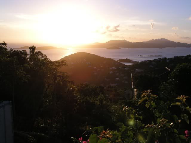
We drove home (straight home, no inadvertent side trips) and rinsed our gear and ourselves in time to try once again see one of those world famous sunsets. This was about as close as we came to that all week - but no complaints here.
We were too full from our late lunch to even consider making dinner, but Leslie was inspired to make drinks, so we had painkillers(me) and margaritas(Les) until sleep finally over took us.
What a day!